
| Version 7 (modified by jdalbey, 7 years ago) (diff) |
|---|
Highway Model Design
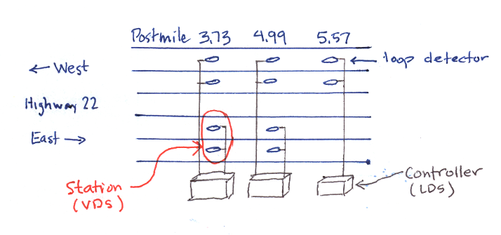
Conceptual diagram showing elements of a highway. 
(See better illustration here: PeMS data sources ).
First draft of data structure for representing a highway network that can model traffic congestion.

Highway (as shown in sketch) is a highway name and a list of VDS's (Vehicle Detector Stations) (not LDS as labeled in illustration).
Intersection is a postmile number and a cross street identifier.
Junction Map is a data structure to model highway intersections (junctions), A map that associates highways to the cross streets that intersect them.
Example Map
Hwy 123: [(17, Hwy 456), (54, Hwy 789)]
Hwy 456: [(93, Hwy 123), (117, Hwy 10A)]
Hwy 789: [(22, Hwy 123)]
In the example Hwy 123 has two cross streets: Hwy 456 at postmile 17 and later at postmile 54 it crosses Hwy 789.
Simulating Congestion
Alternative 1. Every 30 seconds traverse the network from the incident origin point to find the next LDS that is unaffected, then change its state. Pro: Simple concept, needs only the data structures above. Con: In a very large network performance would be slow.
Alternative 2. Maintain a "state" that knows the current extent of congestion and can quickly identify next LDS to be changed. Pro: Better performance. Con: Additional data structures needed.
Decision: We prefer alternative 1. We don't expect out network to be large enough for performance to be a factor. Even a list of thousands of LDS could be traversed in a second and we have 30 second intervals between ATMS updates.
Algorithm overview
The algorithm that models congestion will build a simple FIFO queue of highways starting with the highway on which the incident occurs. Congestion will move linearly opposite the highway direction, advancing one LDS each interval (say 30 seconds). At each interval the list of intersections for this highway will be fetched from the Junction Map and checked to see if a junction has been encountered. If so, the intersecting highway will be added to the queue. After advancing the congestion for each highway in the queue the algorithm ends.
Note that highway direction must be handled as indicated by arrows in sketch above. Congestion on a North/South freeway will backup westward on Eastbound lanes of intersection street and eastward on Westbound lanes of intersecting street. Conversely for East/West freeways.
If two incidents BOTH effect the same highway, use the color of the most severe incident.
Attachments
-
intersection_sketch.jpg
 (60.8 KB) -
added by jdalbey 9 years ago.
(60.8 KB) -
added by jdalbey 9 years ago.
Sketch of a highway intersection showing direction of traffic backup
-
Conceptual Highway Model.2.png
(87.6 KB) -
added by jdalbey 7 years ago.
Conceptual digram of highway model
-
Conceptual Highway Model.png
(87.6 KB) -
added by jdalbey 7 years ago.
Conceptual diagram of highway model

