
| Version 2 (modified by jdalbey, 9 years ago) (diff) |
|---|
Highway Model Design
First draft of data structure for representing a highway network that can model traffic congestion.

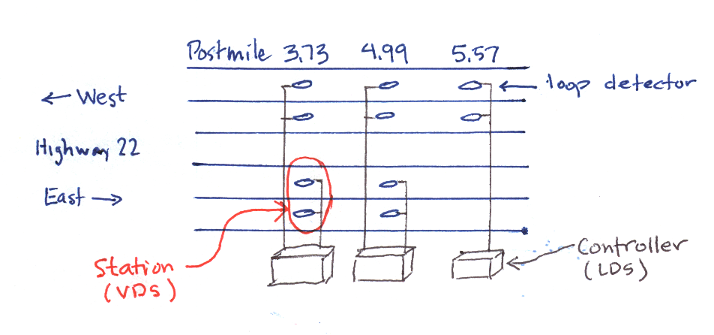
Highway (as shown in sketch) is a highway name and a list of LDS's (Lane Detector Stations).
Intersection is a postmile number and a cross street identifier.
Junction Map is a data structure to model highway intersections (junctions), A map that associates highways to the cross streets that intersect them.
Example Map
Hwy 123: [(17, Hwy 456), (54, Hwy 789)]
Hwy 456: [(93, Hwy 123), (117, Hwy 10A)]
Hwy 789: [(22, Hwy 123)]
In the example Hwy 123 has two cross streets: Hwy 456 at postmile 17 and later at postmile 54 it crosses Hwy 789.
Simulating Congestion
Alternative 1. Every 30 seconds traverse the network from the incident origin point to find the next LDS that is unaffected, then change its state. Pro: Simple concept, needs only the data structures above. Con: In a very large network performance would be slow.
Alternative 2. Maintain a "state" that knows the current extent of congestion and can quickly identify next LDS to be changed. Pro: Better performance. Con: Additional data structures needed.
Decision: We prefer alternative 1. We don't expect out network to be large enough for performance to be a factor. Even a list of thousands of LDS could be traversed in a second and we have 30 second intervals between ATMS updates.
Attachments
-
intersection_sketch.jpg
 (60.8 KB) -
added by jdalbey 9 years ago.
(60.8 KB) -
added by jdalbey 9 years ago.
Sketch of a highway intersection showing direction of traffic backup
-
Conceptual Highway Model.2.png
(87.6 KB) -
added by jdalbey 7 years ago.
Conceptual digram of highway model
-
Conceptual Highway Model.png
(87.6 KB) -
added by jdalbey 7 years ago.
Conceptual diagram of highway model

